


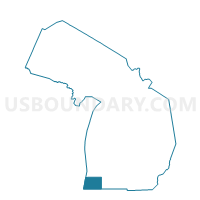
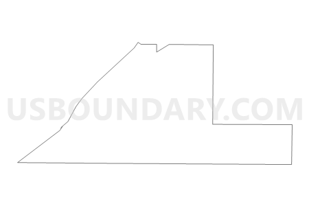
Voting District 0211548000002, Berrien County, Michigan
About
Outline

Summary
| Unique Area Identifier | 596030 |
| Name | Voting District 0211548000002 |
| County | Berrien County |
| State | Michigan |
| Area (square miles) | 12.06 |
| Land Area (square miles) | 11.94 |
| Water Area (square miles) | 0.12 |
| % of Land Area | 98.98 |
| % of Water Area | 1.02 |
| Latitude of the Internal Point | 41.84395300 |
| Longtitude of the Internal Point | -86.63757440 |
Maps


Graphs
Select a template below for downloading or customizing gragh for Voting District 0211548000002, Berrien County, Michigan


Neighbors
Neighoring Voting District (by Name) Neighboring Voting District on the Map
- Voting District 0211548000001, Berrien County, MI
- Voting District 0215723000001, Berrien County, MI
- Voting District 0217974000001, Berrien County, MI
- Voting District 0218512000001, Berrien County, MI
- Voting Districts not defined, Berrien County, MI
Top 10 Neighboring County Subdivision (by Population) Neighboring County Subdivision on the Map
- Chikaming township, Berrien County, MI (3,100)
- Three Oaks township, Berrien County, MI (2,574)
- New Buffalo township, Berrien County, MI (2,386)
- Weesaw township, Berrien County, MI (1,936)
- County subdivisions not defined, Berrien County, MI (0)
Top 10 Neighboring Place (by Population) Neighboring Place on the Map
Top 10 Neighboring Unified School District (by Population) Neighboring Unified School District on the Map
- River Valley School District, MI (7,693)
- New Buffalo Area School District, MI (4,503)
- School District Not Defined (Water), MI (243)
Top 10 Neighboring State Legislative District Lower Chamber (by Population) Neighboring State Legislative District Lower Chamber on the Map
Top 10 Neighboring State Legislative District Upper Chamber (by Population) Neighboring State Legislative District Upper Chamber on the Map
Top 10 Neighboring 111th Congressional District (by Population) Neighboring 111th Congressional District on the Map
Top 10 Neighboring Census Tract (by Population) Neighboring Census Tract on the Map
- Census Tract 113, Berrien County, MI (4,269)
- Census Tract 112, Berrien County, MI (3,100)
- Census Tract 114, Berrien County, MI (2,567)
- Census Tract 116, Berrien County, MI (1,943)
Top 10 Neighboring 5-Digit ZIP Code Tabulation Area (by Population) Neighboring 5-Digit ZIP Code Tabulation Area on the Map
- 49117, MI (3,951)
- 49128, MI (3,715)
- 49125, MI (2,046)
- 49129, MI (609)
- 49116, MI (394)
- 49115, MI (294)